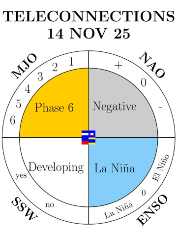

La Niña (Pacific Ocean):
A moderate La Niña is ongoing, enhancing convection near Indonesia and shifting the Walker circulation. This typically energizes the Atlantic jet stream early in winter, bringing wet and mild starts to the season in western Europe. However, as winter progresses, La Niña often promotes Greenland blocking, increasing the risk of Arctic outbreaks into Europe.
Madden–Julian Oscillation (MJO):
The MJO is active in phase 6, favoring enhanced convection over the western Pacific. This phase typically supports downstream ridging over the North Pacific and a more amplified jet stream, which can lead to colder air intrusions into Europe.
North Atlantic Oscillation (NAO):
After a positive start to November, the NAO is trending negative, with high pressure building over Greenland and Iceland. This weakens the westerlies and allows colder Arctic air to spill south into Europe. The UK is already transitioning from a record-warm, wet start to November toward colder, more unsettled conditions.
Sudden Stratospheric Warming (SSW):
A high-pressure anomaly is building over the polar region, pushing into the vortex core. Temperature anomalies in the upper stratosphere are increasing, with wind speeds around the vortex expected to slow. This could lead to a displaced or disrupted vortex during early winter. SSW heralds the onset of cold spells with easterly winds and snow.