Skip to content
Jim Dickson

Jim Dickson

weather, climate, geographic information systems for Kent, UK and global

  • Home
  • About
  • Legal
    • Terms and Conditions
    • Privacy Policy
    • Copyright Notice
    • Disclaimer
  • Contact Form

sources and resources

Posts about data sources and resources used in the production of this blog.

The County of Kent – map by William Mudge 1801, the first map published by the Ordnance Survey.

14/06/202413/06/2024 by Jim Dickson

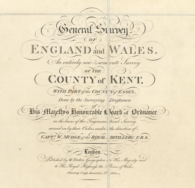
Introducing Capt Mudge RA’s first published Ordnance Survey map as found on the David Rumsey Map Collection website. The map is embedded here and the reader can pan and zoom from this post.

Categories sources and resources Tags historical maps Leave a comment

Integrating LiDAR data into QGIS

13/06/202410/06/2024 by Jim Dickson

a short note about LIDAR and how to connect QGIS to LIDAR data released by the UK Environment Agency.

Categories sources and resources Tags LiDAR Leave a comment

Visual Historical Records – sources of historical maps, aerial photography, lidar and other images.

13/06/202410/06/2024 by Jim Dickson

Some links and discussion about sources of old maps, aerial photography, LiDAR and other historic sketches

Categories General, sources and resources Tags historical maps, historical photographs and drawings Leave a comment

Categories

  • C G Harper drawings – then and now
  • Climate
  • Climate Change
  • General
  • Historical Landscapes
  • out and about
  • Saxon Shore Way
  • seen from space
  • sources and resources

Recent Posts

  • Long term sea level rise legacy for East Kent
  • Ham’s Secret Water – Land Elevation Data and Historical Sea Levels near Eastry Kent
  • Low tide out beyond Hampton Pier
  • The Old Lighthouse, East Quay, Whitstable. C G Harper drawing then and now.
  • Saxon Shore Way – Cliffe to Hoo, the Dickens leg.

Tag Cloud

clouds and weather dog GIS Herne Bay historical maps historical photographs and drawings LiDAR Mudge OS Open Zoomstack public transport rambling route flag satellite view sea level seascape sky stuff on the beach Wantsum Channel West Beach Burtie

© 2025 Jim Dickson • Built with GeneratePress